DRONE-BASED
LiDAR SURVEYING
DJI Matrice 350 RTK drone with Zenmuse L1 LiDAR sensor
EOD-STAR KFT.
Reusable data
Lower project risk
Time and cost savings
data acquisition by drone
OVERVIEW
WHAT IS DRONE-BASED LiDAR SURVEYING?
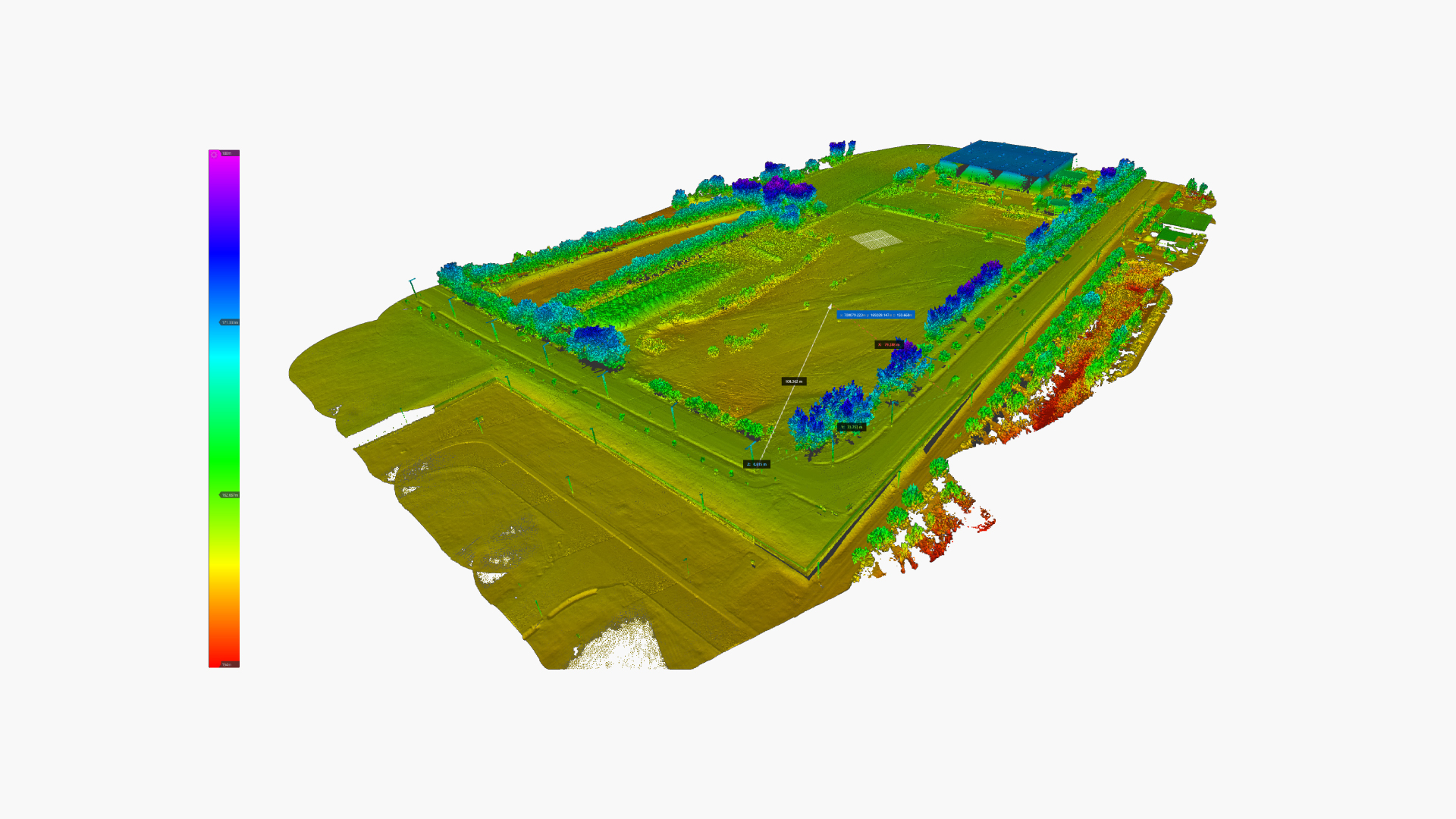
Drone-based LiDAR (Light Detection and Ranging) surveying is one of the most advanced terrain data acquisition methods available today. It enables fast, accurate and objective mapping of large areas.
This technology is especially beneficial in projects where precise terrain information is critical for planning, execution and risk reduction. It performs effectively even on complex surfaces and in areas covered with vegetation.
APPLICATIONS
WHY IS DRONE-BASED LiDAR SURVEYING ADVANTAGEOUS?
Compared to traditional land surveying and photogrammetry, LiDAR is an active laser-based measurement method that captures not only the surface, but also its true elevation characteristics.
Laser pulses can partially penetrate vegetation, allowing accurate terrain modeling even in forested or densely vegetated areas.
As a result, a comprehensive dataset is generated that can be reused across multiple project phases without the need for repeated field surveys.
terrain model
APPLICATIONS
WHAT OUTPUTS CAN DRONE-BASED
LiDAR SURVEYING PROVIDE?
LAS-LAZ
POINT CLOUD DATA
DEM-DTM | GEOTIFF
DIGITAL TERRAIN MODEL

DXF-DWG
CONTOUR MAP

What We Offer
POINT CLOUD DATA
LAS-LAZ
The basis of LiDAR surveying is a three-dimensional dataset composed of millions of measured points, where «LAS» represents the standard format and «LAZ» is the compressed version.
APPLICATION POSSIBILITIES:
- Preparation of detailed spatial analyses
- Post-survey measurements and verification
- Volume and elevation difference calculations
- Subsequent data reprocessing and application of new filters
- Long-term digital archiving
- Use as base data for further processing
What We Offer
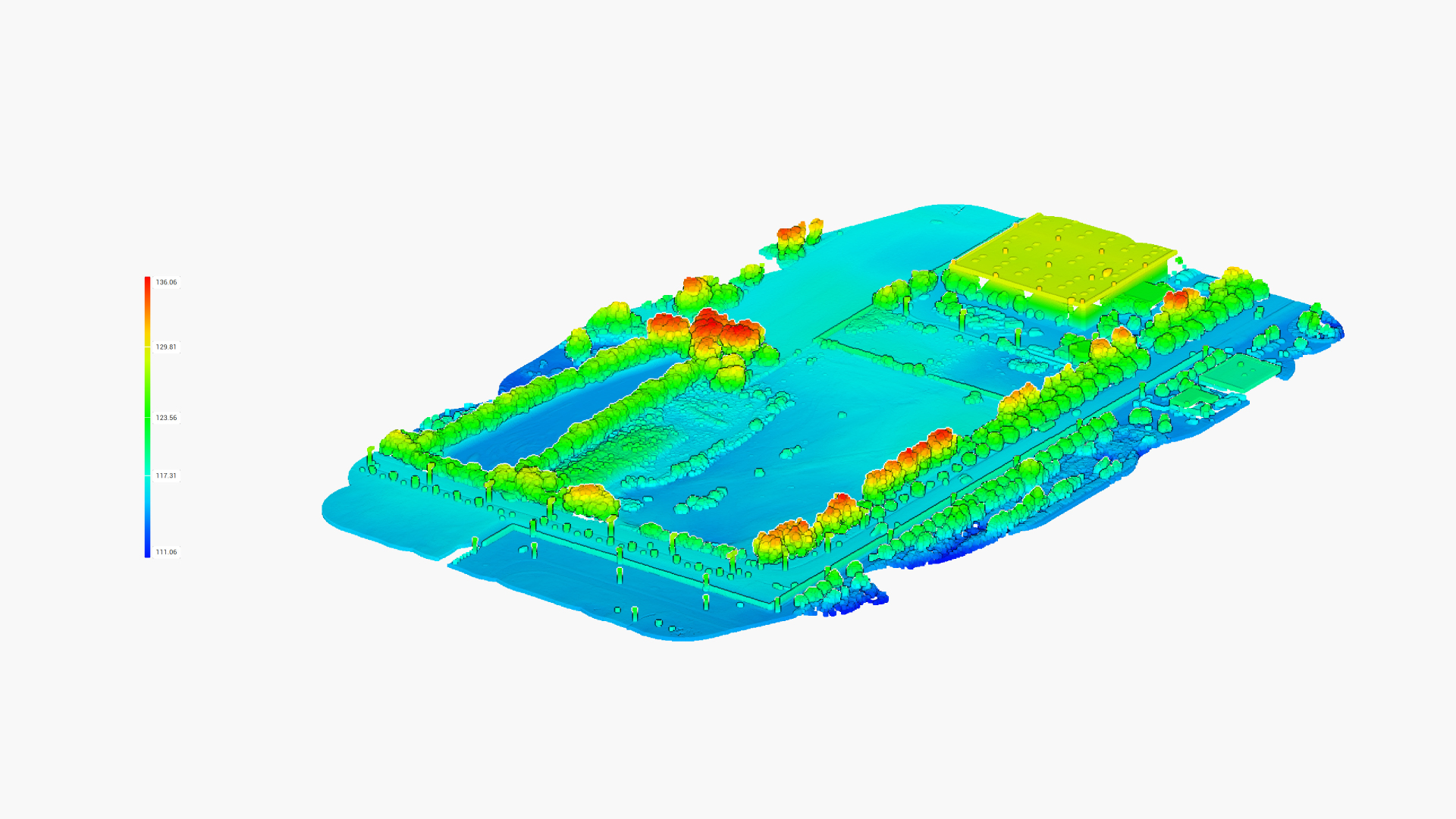
DIGITAL TERRAIN MODEL
DEM-DTM | GEOTIFF
The digital terrain model represents the terrain surface, cleaned from vegetation and artificial objects, in a continuous and gridded format. The GeoTIFF format ensures accurate georeferencing and software-independent usability.
APPLICATION POSSIBILITIES:
- Slope and gradient analysis
- Water flow and drainage modelling
- Earthwork and volume calculations
- Preparation of base layers for design in CAD and GIS environments
What We Offer
CONTOUR MAP
DXF-DWG
The contour map represents terrain elevation in a clear and visual format. The «DXF» and «DWG» formats can be used directly in AutoCAD and Civil 3D environments.
APPLICATION POSSIBILITIES:
- Preparation of design and permitting documentation
- Preparation for decision-making and regulatory coordination
- Preparation of construction workflows
What We Offer
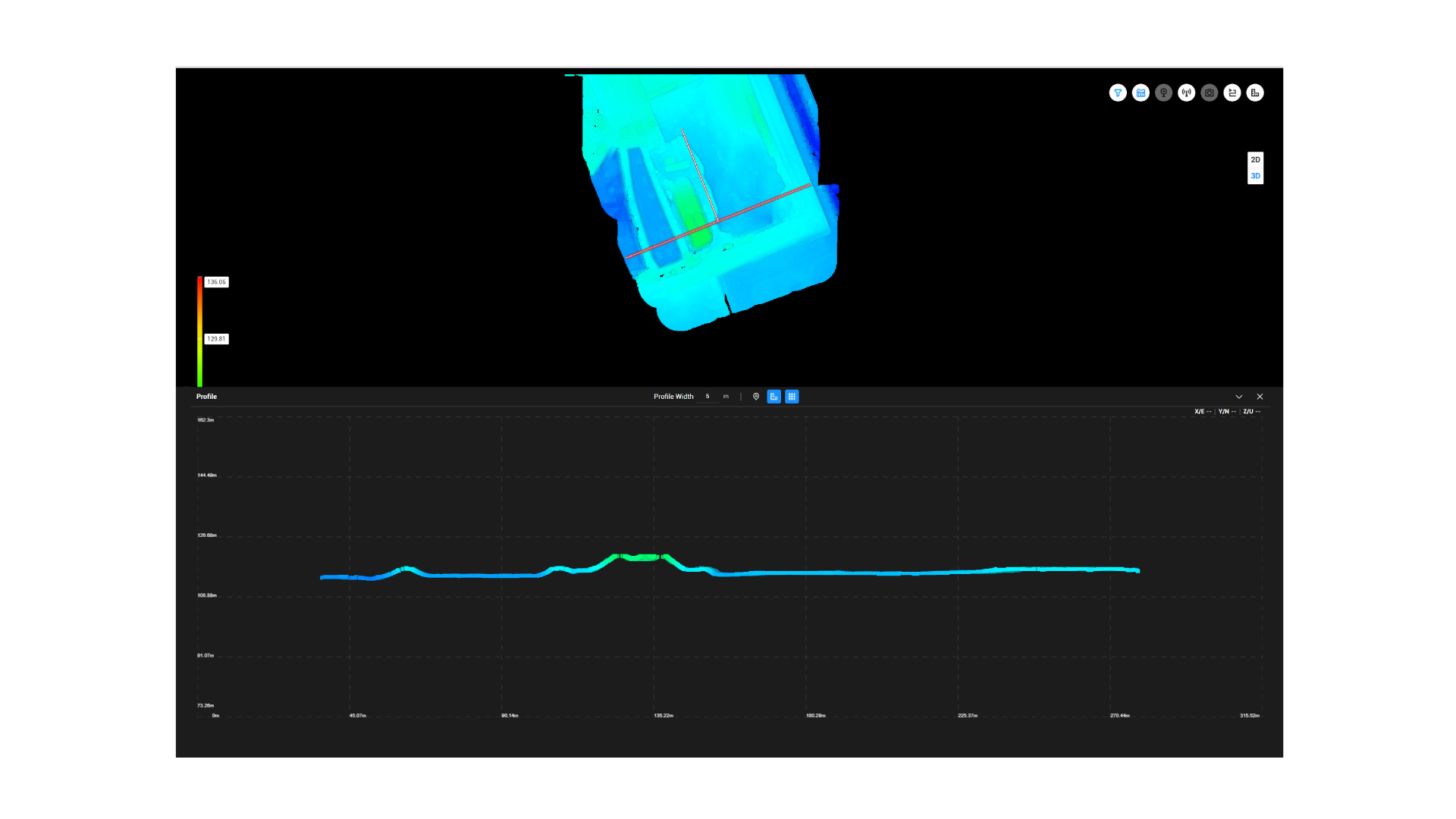
CIVIL 3D
SURFACE MODEL
In a Civil 3D environment, a directly editable surface model can be created from the measured data, from which sections, longitudinal and cross profiles, as well as additional contour lines can be generated.
APPLICATION POSSIBILITIES:
- Fast generation of contour lines, sections and longitudinal profiles
- Analysis and quick comparison of design alternatives
- Acceleration and/or simplification of the design process
- More accurate preliminary quantity estimation
What We Offer
MAP VISUALIZATION
The «PDF» format map attachment is a scaled, well-structured and clearly presented material with legend, suitable for both printing and digital sharing.
APPLICATION POSSIBILITIES:
- Support for decision-making
- Support for regulatory control
- Support for on-site inspections
ADVANTAGES
WHY IS DRONE-BASED LiDAR SURVEYING WORTH IT?
WHAT ARE THE TECHNICAL ADVANTAGES OF DRONE-BASED LiDAR TECHNOLOGY?
- Multiple types of data can be derived from a single survey.
- Significant time and cost savings can be achieved.
- More accurate planning with reduced execution risk.
- Further analyses can be performed without resurveying the area.
- Creates a long-term, reusable and valuable dataset.
WHAT ARE THE ECONOMIC ADVANTAGES OF DRONE-BASED LiDAR TECHNOLOGY?
- Surveying large areas in a short time.
- Efficient data capture even in complex or hard-to-access terrain.
- Fast tracking of design changes.
- Minimization of execution risks.
A
=======
drone-based
LiDAR surveying
does not replace, but
complements traditional
surveying,
while in large-scale,
complex projects it provides
significant
time and cost savings,
as well as lower project
risk,
resulting in more efficient outcomes. Traditional
surveying
often requires multiple site visits, whereas
data cap-
tured using drone-based LiDAR technology
can be further analyzed
through
data reprocessing and most questions
can be answered without
============================== on-site presence
==============================
SERVICES
UAV-BASED LiDAR DATA ACQUISITION
AND BIM MODEL COMPARISON SERVICES
LORICATUS
003 | 006 | 012
On-site technical survey and drone data acquisition.
LORICATUS
010
GNSS RTK-based control point marking, EOV georeferencing.
LORICATUS
013
Point cloud cleaning, noise filtering, removal of irrelevant elements.
LORICATUS
015 | 016
Integration of LiDAR and photogrammetry data into a unified system, orthophoto creation.
LORICATUS
039 | 040
GIS analysis, digital terrain database creation and monitoring support.
Additional (1)
Point cloud generation from laser scanning (LiDAR) of industrial objects
Additional (2)
Creation of design base layers in CAD and GIS environments
LORICATUS
047 | 048 | 045
Point cloud and BIM model comparison services
Services
Services not provided
by our company
are not included in our service scope are listed below.